
Green Hill [Bail Hill]
Good walks are even better shared.
Overview
Green Hill (Bail Hill)
Location & Overview
Green Hill, also known as Bail Hill, is a humble yet charming peak located in the Southern Uplands of Scotland. With an elevation of 233 meters, it may not compete with the towering Munros, but it makes up for its modest height with delightful views and scenic routes.
Geology
This hill is composed mainly of sandstone and shale, which narrate the ancient geological history of the area. These sedimentary rocks emerged during the Carboniferous period, providing a distinct geological flavour to the region that many outdoor aficionados appreciate.
Routes
The most recommended route is the Bail Hill Circular Route, which stretches approximately 8 km and takes about 3 hours to complete. This moderate trek begins in Newtown St Boswells and meanders around the foothills before ascending. Expect some delightful surprises along the way, and don’t forget to pack a snack or two!
Summit Features
Once you reach the summit, you’re greeted by a quaint stone cairn—a perfect photo op! Here, you might rub shoulders with local sheep who always seem to have something on their minds.
Terrain Type
The majority of the terrain is grassy, punctuated by rocky outcrops and patches of heather. Beware of boggy sections, which can easily trick you into a surprise mud bath!
Views
Atop Green Hill, you're treated to sweeping views of the Merse and the Border Hills, featuring sights such as the Eildon Hills and the far-off Cheviots. Ideal times for capturing these views are in late spring and early autumn, when the landscape bursts with colour.
Hazards
While the hill can be inviting, stay alert for swiftly changing weather conditions. Fog is known to sneak in, and when the ground is wet, it’s best to tread carefully to avoid slippery patches.
Nearby Summits
If you’re keen on collecting summits, nearby peaks such as Black Hill (258 meters) and Kershope Forest Hill (253 meters) are just a stone's throw away.
Access
Getting here is a piece of cake! The nearest parking is available in Newtown St Boswells, just a short drive from the trailhead. Public transport is also feasible, with options linking to Melrose and Galashiels.
Facilities
In Newtown St Boswells, facilities include a few charming cafes and a shop for any supplies you may have forgotten. Thankfully, public toilets are also available!
History
The meaning of the name 'Bail' likely references its origins from Old Norse, indicating a mound. The area is rich in history—once a thoroughfare for clans in the Borders who were known for their fierce encounters and a penchant for sheep. So, watch out for any woolly characters looking to steal a bite of your lunch!
With its stunning vistas and rich history, Green Hill is a rewarding climb that promises a delightful outing for hikers and nature lovers alike. Don't forget your camera!
Happy hiking!
Explore routes near Green Hill [Bail Hill]
Public walks starting within 80 km of this hill. Nearby does not mean a route reaches the summit; check its map and access before setting out.
Forest of Ae Water of Ae Riverside Trail
View route
Carrick Forest Drive: Stinchar Bridge to Loch Doon
View route
Mabie Forest Dalshinnie Glen and Loch
View route
Castle Douglas Carlingwark Loch and Lover’s Walk Circuit
View route
Route planning notes
These notes describe possible approaches, not verified navigable routes or permission to cross land. Check current paths, local access rules and conditions before setting out.
Bail Hill Circular Route
A scenic circular route starting from the village of Newtown St Boswells that takes you around the foothills before ascending to the summit, with stunning views of the surrounding countryside.
Make a day of it, together
Find someone to share the walk with, or organise a day out along a route you like.
Hill facts and local notes
Classifications
Elevation
547m
1,795 ft
Prominence
121m
Coordinates
55.2438, -4.0050
NX726962
OS Map
77
Explorer: 328S
At the Summit
The summit features a small stone cairn, marking the highest point of Green Hill. From there, you can often find local sheep engrossed in their own meetings, probably discussing the price of grass.
Terrain & Geology
The hill is primarily composed of sedimentary rocks, including sandstone and shale, characteristic of the Southern Uplands geological formation, which dates back to the Carboniferous period. This makes for a captivating study of ancient tectonic processes and provides a rich habitat for diverse flora and fauna.
Views & Scenery
From the summit, you can enjoy panoramic views of the Merse and the Border Hills, with landmarks such as the Eildon Hills and the Cheviots prominent in the landscape.
History & Heritage
Name Origin
The name 'Bail Hill' is thought to derive from Old Norse influences, with 'bail' referring to a mound or hillock.
Historical Significance
Historically, this region was part of the ancient lands of the Borders, an area steeped in tales of clan rivalries and sheep stealing, so keep an eye on any woolly characters!
Getting There & Facilities
Check current local access restrictions, parking rules and transport timetables before travelling. These notes do not confirm public access to the summit.
Parking
There is a small car park in Newtown St Boswells, just a short walk from the trailhead for the circular route.
Public Transport
Regular bus services connect Newtown St Boswells with nearby towns like Melrose and Galashiels.
Nearby Facilities
The nearest facilities are located in Newtown St Boswells, where you can find a few cafes, a small shop, and public toilets.
Safety Information
Known Hazards
- Be mindful of changing weather conditions, as fog can roll in unexpectedly. The terrain can also be slippery when wet, particularly in boggy areas.
General Safety Tips
- Check weather conditions before setting out
- Carry appropriate clothing and equipment
- Let someone know your planned route
- Take a map, compass, and GPS device
- Carry emergency supplies: food, water, first aid kit, torch
Hills
Some common questions about the hills answered
Are there group walks up Green Hill [Bail Hill]?
Many walkers use Walkmates to join or organise walks with others. You can check for group walks around Green Hill [Bail Hill] through the maps
Are there other walkers around Green Hill [Bail Hill]?
Activity varies by location and time, but Walkmates lets you see whether others have shared walks or shown interest in this area. Find other people through the walking friends search walking friends for Green Hill [Bail Hill] search or of course create your own walk for Green Hill [Bail Hill]
Can I organise a walk to Green Hill [Bail Hill]?
Yes. If there aren’t any walks listed already, you can create a walk and make it available for others to join.
If you're signed up to Walkmates, you can create a walk to Green Hill [Bail Hill].
How do I find a walk up this hill?
There are often multiple ways to walk this hill, depending on experience and route preference. Walkmates helps you explore walks and routes that others have shared.
Can I suggest a new route up Green Hill [Bail Hill]?
Yes. You can suggest or create routes to share with others. Walkmates focuses on the social side of walking, so routes are used to help people organise walks and explore areas together, rather than as detailed navigation tools or route libraries.
Other uses really appreciate knowledgeable walkers sharing their routes. Share your favourite route to Green Hill [Bail Hill] here
The is an error or something incorrect about this hill. How do I let you know?
We always strive to keep the information on Walkmates as accurate as possible. If you find an error, please let us know through the contact form and we'll aim to correct it as quickly as possible
Community Discussion
Comments
Location
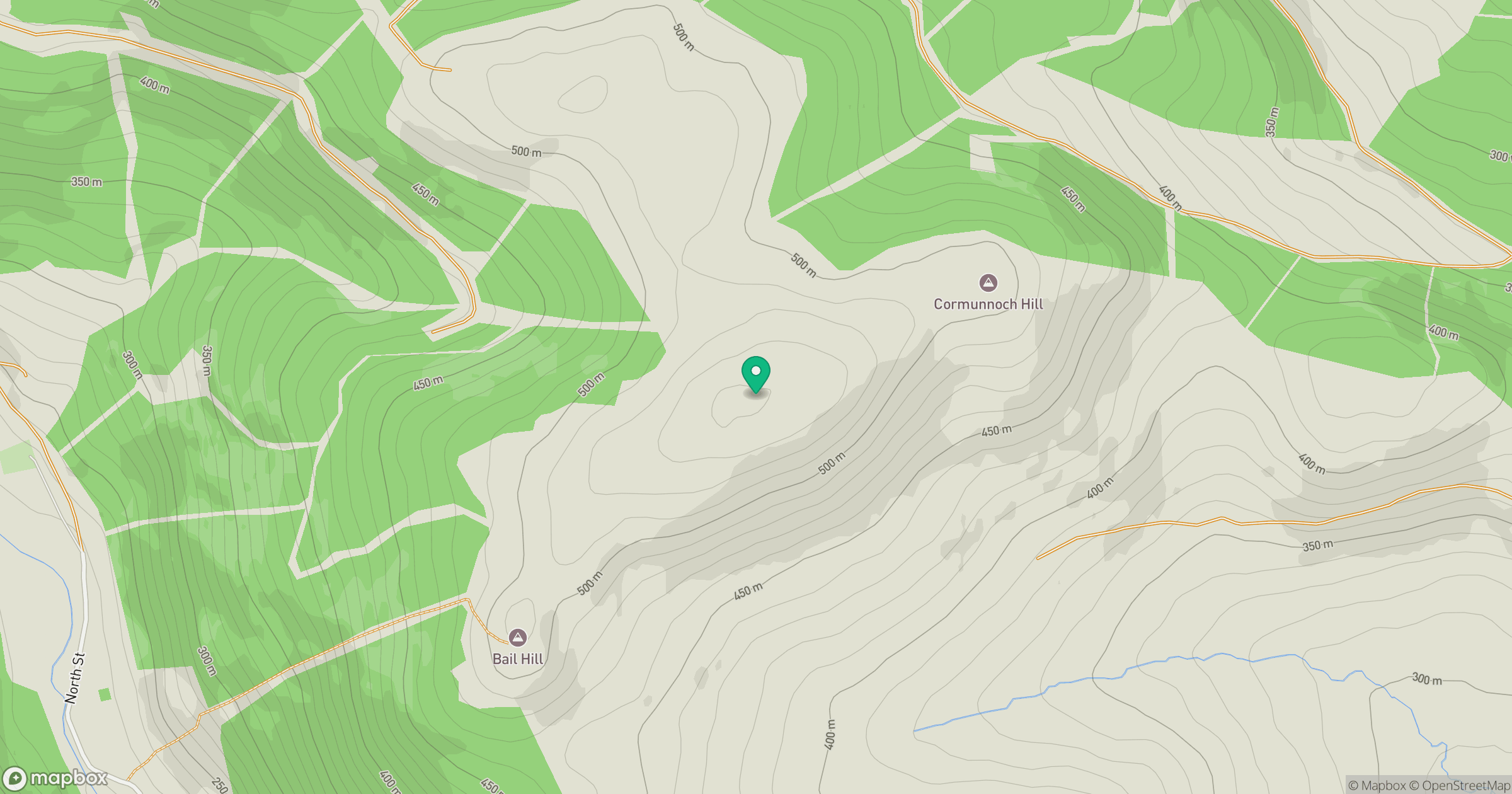
Grid reference: NX726962
View on OpenStreetMapOpens a map in a new tab, centred on the hill.
Hills within 30 km
Straight-line distance, not a walking route or confirmation of access.
No comments yet. Be the first.